


-
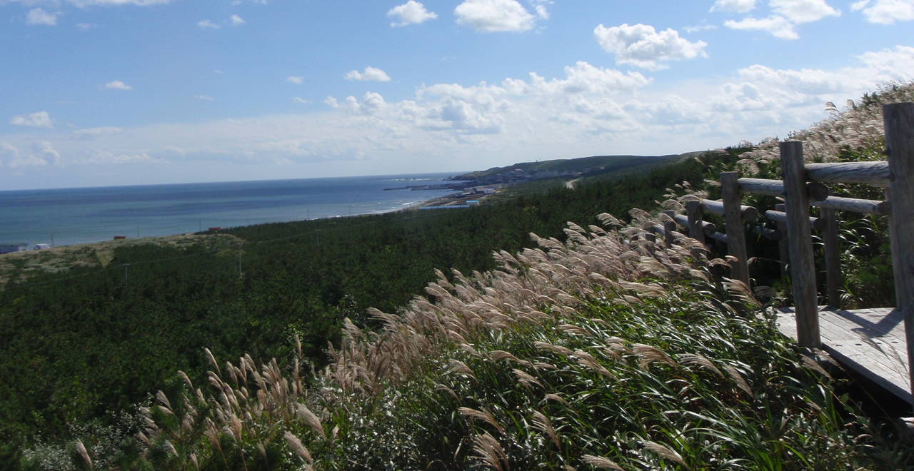
Silver grass near the coast
-
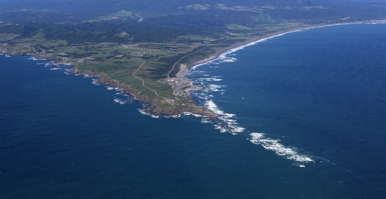
Aerial view of the Cape Erimo
-
Hiren-numa pond
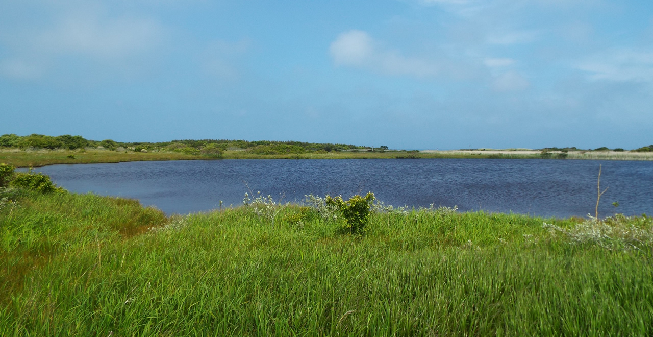
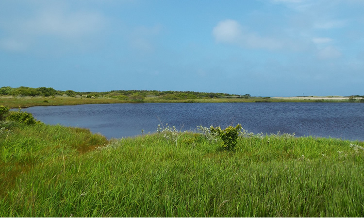
-
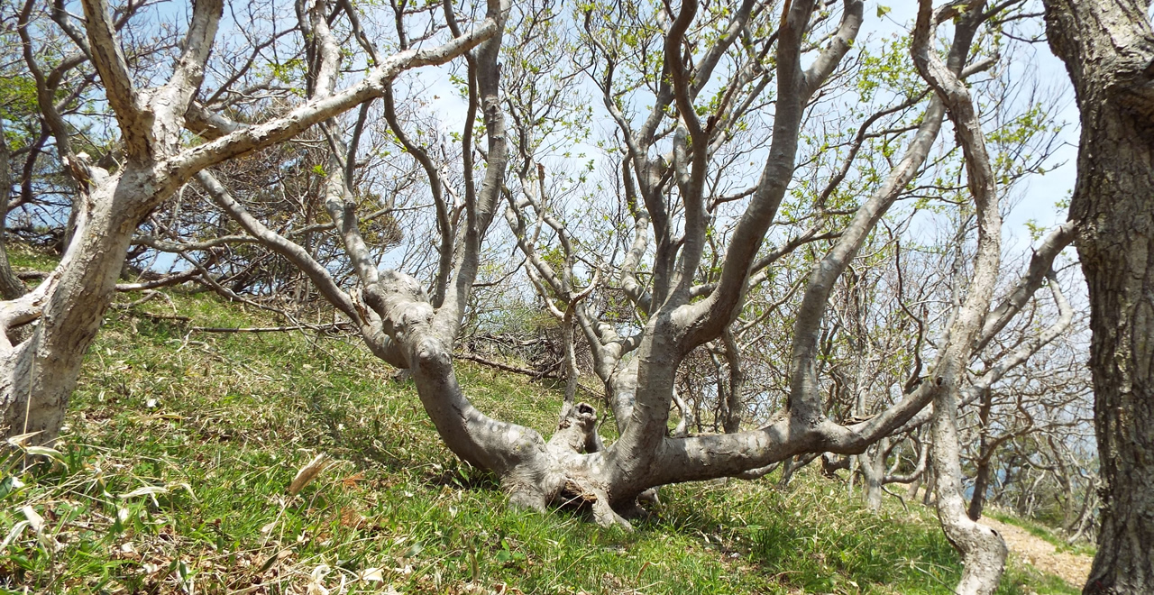
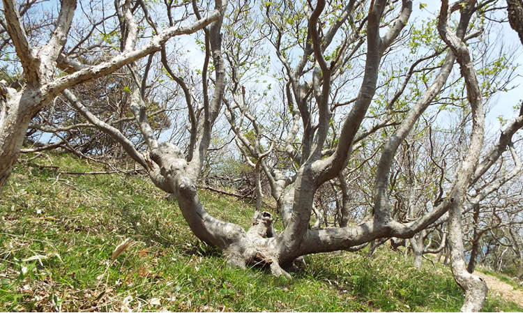
Wind-deformed Trees
Erimo Recreation Forest
419.57ha
Elevation Mainly : 5―70m
Keeping alive the memory of the Erimo Desert's transformation into a forest
Keeping alive the memory of the Erimo Desert's transformation into a forest
- Newest information
- Area
- Activities
- Overview
- Latest Information
- Usage Guide
- Facility
- Map
- Location
- Access
(Distances and times are
provided as a guide only) - Management office
contact details - Information on Other Local
Tourist Attractions - Official Tourist Information
- Recreation Forest
Management Committee - Supporters
- Other
- Newest information
- CHECK
Please visit official tourism websites for the latest updates and information.
- Area
- Hokkaido
- Activities
- Overview
-
- Geographical/topographical features
- Hilly terrain located at an elevation of 5–70 m. The name Erimo comes from the Ainu word “Enrum,” meaning “jutting out point”
- Historical/cultural features
- The coastal forests of Erimo area were devastated by logging and livestock grazing in the course of development during the Meiji period and the area suffered desertification. Following requests by the municipality and local citizens to restore the area's greenery, a forest and grassland regeneration project was launched in 1953.
This project was carried out with the assistance of the local community. Gota (an inedible seaweed) washed up on the shore was used to prevent the ground's surface from drying out and as a fertilizer in a process involving repeated trial and error.
In addition to low temperatures and strong winds, the Erimo area frequently experiences fog; the consequent lack of sufficient sunlight means that plants do not grow well, making reforestation difficult.
Now, more than 60 years after the project began, the area is covered with herbaceous plants and forest.
Details of the Erimo National Forest Conservation Project can be found at the following web page (Only Japanese version available).
https://www.rinya.maff.go.jp/hokkaido/hidakananbu/conservation.html - Climate, flora and fauna
- With an annual mean wind speed of 8.3 m/s, this is one of Japan's highest wind areas, with wind speeds of 10 m/s or more recorded on at least 260 days per year. It also frequently experiences fog, with thick fog recorded on 100 days or more each year. There are said to be around 20 days of thick fog per month on average between May and August. The coastal forest is mainly planted with kuromatsu, Japanese black pine (Pinus thunbergii) and kashiwa, daimyo oak (Quercus dentata). The number of ezoshika, Yezo sika deer (Cervus nippon yesoensis) has been on the rise in recent years.
- Attractions
- The observation platforms and the administration building (Hyakunin-hama), which is located 13 m above the ground, offer panoramic views over the forest brought back to life from a desertified state thanks to a reforestation program. Boardwalks and woodchip footpaths have been laid to provide walking trails.
Together, the national forests centered on Cape Erimo are designated as the Hidaka Sanmyaku-Erimo Quasi-National Park. The steep cliffs and rocky reefs of the cape are a magnificent sight. The surrounding area is home to many other beauty spots, including the Hidaka Yabakei area, the Golden Road, and Hiren-numa Marsh.
The Midorikan (Forestry Information Center) exhibits handcrafted tools used in the above-mentioned reforestation program, which began in the 1950s, and panels and a DVD outlining the history of the program.
- Latest Information
-
- Information on temporarily unavailable facilities
- -Late April Erimo Uni (sea urchin) Festival
-Mid-August Erimo Lighthouse Festival
-Late September – late October Helicopter sightseeing flights around Lake Toyoni (flights taking in both Lake Toyoni and Cape Erimo is available)
-Early October Erimo Umi to Yama no Sachi (Gifts From the Sea and Mountains) Festival
- Usage Guide
-
- Entrance fee
- Free
- Opening seasons and hours
- Open all year.
However, the administration building (Hyakunin-hama) is only open between late April and mid-October, from 9AM to 5PM,
while the Midorikan is only open between April and December, from 9AM to 5PM. - Accommodation options
- There are five options near Cape Erimo and five in Erimo town center (20 minutes by car).
There is also the Hyakunin-hama Auto-camping Site (open April 20 – October 20). (5 minutes by car from Hyakunin-hama)
- Facility
- Toilets and drinking fountains(Includes surrounding area) Walking trail Car park Observation platform Vending machine(Includes surrounding area) Shop(Includes surrounding area) Restaurant(Includes surrounding area) Campsite and/or cabins(Outside the forest) Accommodation facilities (Hotels / Japanese inns)(Outside the forest)
- Map
- Location
- Cape Erimo (Erimo-misaki), Erimo-cho, Horoizumi-gun, Hokkaido
- Access
(Distances and times are provided as a guide only) -
- By public transport
-
<Access from nearest railway station / bus stop>
- ・Misaki Shogakko-mae bus stop → No. 1 Observation Platform (12 minutes on foot)
- ・Hyakunin-hama bus stop → Administration building (5 minutes on foot)
<Access from major transport hubs to nearest railway station / bus stop>- ・Sapporo Station (highway express bus: 160 minutes) → Shizunai (JR Hidaka Line rail replacement bus: 112 minutes) → Samani Station (Hiroo – Samani local bus: 60 minutes) → Erimo-misaki / Misaki Shogakko-mae / Hyakunin-hama
- ・New Chitose Airport (bus bound for Tomakomai: 29 minutes) → Numanohata Kita (bus bound for Shizunai Eki-mae: 127 minutes) → Shizunai (JR Hidaka Line rail replacement bus: 112 minutes) → Samani Station (Hiroo – Samani local bus: 60 minutes) → Erimo-misaki / Misaki Shogakko-mae / Hyakunin-hama
- JR Hidaka Main Line between Mukawa and Samani is closed: Rail replacement bus service is available.
- By car
-
<Access>
- ・Sapporo Station entrance → Sasson Expressway Sapporo-kita IC → Hokkaido Expressway Sapporo JCT → Hokkaido Expressway Tomakomai-higashi IC → Hidaka Expressway Monbetsu IC → Route 235 → Route 336 → Pref. Route 34 → Erimo Recreation Forest (240 km / 4 hours 10 minutes)
- ・New Chitose Airport → Hokkaido Expressway → Hidaka Expressway Monbetsu IC → Erimo Recreation Forest (180 km /3 hours 30 minutes)
<Car parking capacity / parking charges>Space for 10 vehicles Free of charge
- Nearby tourist facilities
-
- ・Cape Erimo: 5 minutes by car from the Erimo Wind Museum to the entrance to the No. 1 Observation Platform
- ・45 minutes by car from Mt. Apoi Geopark (Samani-cho)
- Management office contact details
-
Hidaka Nanbu District Forest Office, Hokkaido Regional Forest OfficeTEL:0146-42-1615
FAX:0146-42-1616
https://www.rinya.maff.go.jp/hokkaido/hidakananbu/index.html
- Information on Other Local Tourist Attractions
-
Erimo-cho, Hokkaido [External link]
- Official Tourist Information
-
Hokkaido Erimo Town Sightseeing Navi [External link]
- Recreation Forest Management Committee
-
Erimo Recreation Forest Management Committee
(Industry Promotion Division, Erimo Municipal Office)
- Supporters
- ー
- Other
- ー
PDF形式のファイルをご覧いただく場合には、Adobe Readerが必要です。
Adobe Readerをお持ちでない方は、バナーのリンク先からダウンロードしてください。
![]()